CRUISE REPORT
Cruise Number: EW02-05
FOCI Number: 1EW02
Ship: Maurice Ewing
Area of Operations:
Itinerary:
Participating Organizations:
NOAA Pacific Marine Environmental Laboratory
AFSC/RACE/FOCI
Chief Scientist:
William Floering
NOAA/PMEL
206-526-6480
William.Floering@noaa.gov
Personnel: 12 May – 25 May
Dr. Calvin Mordy NOAA/PMEL
Carol DeWitt NOAA/PMEL
Doug Jongeward NOAA/PMEL
Tim Nesseth NOAA/PMEL
Steve Smith NOAA/PMEL
James Bunn NOAA/PMEL
David Wisegarver NOAA/PMEL
Personnel: 22 May – 25 May
Dr. Jeff Napp AFSC/RACE/FOCI
Jennifer Lanksbury AFSC/RACE/FOCI
Charles Greenlaw BAE Systems
Objectives of Cruise:
1. To recover and deploy subsurface and surface oceanographic instrumentation moorings in support of
2. To complete CTD casts for mooring instrument calibrations and to further identify ocean structure and water movements in this area.
Summary of Operations:
(Statistical data: Number of specific operations and samples collected from COD.)
Operations:
CTD casts 85
Mooring deployment 26 (2 surface, 24 sub-surface)
Mooring recoveries 15 (1 surface, 14 sub-surface)
Satellite tracked buoy deployment 1
Samples Collected:
CTD salinity comparison samples 82
Chlorophyll samples 142
Nutrient samples 545
Summary of Cruise:
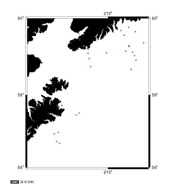
The primary objective of this cruise was to recover and deploy an extensive array of oceanographic moorings. Mooring related activities were usually accomplished during hours of daylight (0700-2300). CTD casts were completed in conjunction with mooring recoveries and deployments, CTD lines were completed primarily during the night. Within this report are tables listing the times and dates each mooring was recovered or deployed and a table listing the position, time and date of each CTD cast. There is also a chart of each mooring location and one showing each CTD cast location.
We
departed
South
of
We
deployed the FATE subsurface ADCP profile mooring and with some difficulty
recovered the FATE surface mooring. It
appears the surface FATE mooring was deployed with a longer then expected
mooring line causing the acoustic release to lay horizontal on the ocean
bottom. The acoustic release would not
operate correctly until we recovered enough of the surface mooring (anchor
attached) to pull the release into a vertical orientation. At that point the release responded properly,
dropped the 5000 lb anchor and we were able to recover the remainder of the
mooring. The 2002 FATE surface mooring
was then deployed without incident. A
single
We moved north toward Seward to the first of 13 moorings on the GLOBEC line. With the exception of GBM3, a surface mooring, the recoveries and deployments along this line were routine and successful. Please refer to the mooring table and chart of mooring locations for the dates and times these moorings were completed.
Arriving
at GBM3 we could not visually locate the 9 foot diameter mooring surface float
and due to the earlier failure of the
On
22 May we broke operations to complete a touch and go inport
in Seward
Following the personnel transfer at Seward we steamed back to the GBM3 location. A new GBM3 surface mooring was deployed along with a subsurface mooring that included the acoustic plankton counter and an iron sampler.
Completing the planned operations on the GLOBEC line we steamed west to a line of 3 subsurface moorings south of Gore Point. The recovery and deployment of GP32, 34 and 36 was routine and without incident.
Following
our operations on the Gore Point line we steamed west to the inshore
The work at CB1 marked the end of Cruise EW-02-05 and the completion of our objectives. We arrived at the Kodiak Coast Guard Base the afternoon of May 24th, approximately 14 hours ahead of our original schedule.
Summery of Mooring Operations:
Summery of CTD Stations:
R/V
CTD# MAY
GMT Latitude Longitude Depth
1
13 7:3854 deg 18.03N
164 deg 44.25W 85 M
2 15 9:0056 deg 58.96N
152 deg 26.93W 140 M
3 15 11:1056 deg 44.17N
152 deg 32.12W 156 M
4 15 12:0556 deg 43.18N
152 deg 29.91W 168 M
5 15 13:0556 deg 42.37N
152 deg 27.44W 188 M
6 15 13:5356 deg 41.49N
152 deg 24.93W 175 M
7 15 14:3956 deg 40.65N
152 deg 22.30W 88 M
8 15 18:0556 deg 41.14N
152 deg 24.40W 157 M
9 16 0:1657 deg 27.57N
151 deg 34.76W 112 M
10 16 3:0757 deg 30.92N
151 deg 26.23W 137 M
11 16
20:3158 deg
15.39N 147 deg 41.05W 2369 M
12 17 3:5058 deg 14.88N
147 deg 40.00W 2367 M
13 17 7:0658 deg 15.89N
147 deg 32.02W 2102 M
14 17 10:0058 deg 20.57N
147 deg 39.80W 2100 M
15 18 0:3958 deg 13.07N
147 deg 44.40W 2350 M
16 18 10:3458 deg 15.69N
147 deg 41.22W 2369 M
17 18 12:4958 deg 18.37N
147 deg 50.30W 1959 M
18 18 17:4058 deg 31.48N
148 deg 54.97W 115 M
19 18
18:5458 deg
36.58N 148 deg 53.00W 116 M
20 18 22:1659 deg 02.35N
148 deg 42.00W 197 M
21 19 1:1859 deg 02.80N
148 deg 41.82W 191 M
22 19 2:3358 deg 55.70N
148 deg 34.41W 246 M
23 19 6:3458 deg 55.30N
148 deg 37.79W 259 M
24 19 9:2558 deg 41.96N
148 deg 51.56W 206 M
25 19 11:0158 deg 31.48N
148 deg 54.96W 114 M
26 19 11:2758 deg 31.43N
148 deg 55.03W 116 M
27 19 12:2358 deg 36.77N
148 deg 52.96W 117 M
28 19 13:2858 deg 41.95N
148 deg 51.02W 212 M
29 19 14:4358 deg 47.74N
148 deg 49.41W 254 M
30 19 16:0158 deg 53.47N
148 deg 47.03W 292 M
31 19 17:2258 deg 57.99N
148 deg 44.34W 252 M
32 19 18:3059 deg 02.54N
148 deg 41.41W 199 M
33 19 19:4359 deg 07.62N
148 deg 47.31W 144 M
34 19 23:2459 deg 07.74N
148 deg 46.53W 144 M
35 20 1:4659 deg 16.46N
148 deg 57.86W 189 M
36 20 7:3558 deg 42.98N
149 deg 16.53W 157 M
37 20 8:3458 deg 46.83N
149 deg 14.99W 181 M
38 20 9:4958 deg 52.94N
149 deg 13.03W 201 M
39 20 10:4358 deg 56.05N
149 deg 12.00W 215 M
40 20 11:3758 deg 59.16N
149 deg 10.97W 226 M
41 20 12:4859 deg 05.32N
149 deg 08.86W 146 M
42 20 13:5059 deg 09.52N
149 deg 08.34W 171 M
43 20 17:3659 deg 09.81N
149 deg 07.56W 173 M
44 20 20:5059 deg 21.72N
148 deg 15.05W 173 M
45 20 23:0659 deg 22.24N
148 deg 14.75W 175 M
46
21 1:3759 deg 38.60N
148 deg 39.22W
Summery
of CTD Stations (cont.):
47
21 3:5759 deg 39.52N
148 deg 39.69W 185 M
48 21 5:2859 deg 45.71N
148 deg 58.12W 196 M
49 21 6:5659 deg 45.77N
148 deg 58.22W 196 M
50 21 15:4858 deg 23.33N
148 deg 04.43W 1415 M
51 21 18:2558 deg 32.61N
148 deg 12.66W 1455 M
52 21 20:1758 deg 40.75N
148 deg 20.99W 276 M
53 21 21:4258 deg 47.50N
148 deg 29.39W 288 M
54 21 23:2458 deg 58.36N
148 deg 37.81W 242 M
55 22 0:4459 deg 06.99N
148 deg 46.24W 151 M
56 22 2:0459 deg 15.62N
148 deg 54.55W 168 M
57 22 3:2559 deg 24.58N
149 deg 03.08W 202 M
58 22 5:0159 deg 34.10N
149 deg 15.53W 224 M
59 22 10:1059 deg 33.95N
149 deg 12.15W 214 M
60 22 11:3959 deg 41.56N
149 deg 19.61W 225 M
61 22 14:4759 deg 49.74N
149 deg 27.10W 275 M
61-A 22
15:2559 deg
50.19N 149 deg 27.42W 270 M
62 22 19:3559 deg 41.84N
149 deg 22.35W 245 M
63 23 1:0459 deg 42.05N
149 deg 21.19W 245 M
64 23 9:5858 deg 40.82N
149 deg 16.87W 137 M
65 23 11:1258 deg 46.74N
149 deg 15.30W 179 N
66 23 12:2058 deg 52.95N
149 deg 13.09W 205 N
67 23 13:1358 deg 56.09N
149 deg 11.96W 216 M
68 23 14:0958 deg 59.13N
149 deg 10.88W 223 M
69 23 15:1759 deg 05.30N
149 deg 08.93W 147 M
70 23 23:0459 deg 17.78N
148 deg 57.77W 187 M
71 24 5:2958 deg 46.54N
150 deg 05.00W 156 M
72 24 6:2758 deg 52.27N
150 deg 05.08W 187 M
73 24 7:3458 deg 58.01N
150 deg 05.07W 222 M
74 24 8:4059 deg 03.53N
150 deg 04.81W 204 M
75 24 10:1959 deg 06.02N
150 deg 05.00W 189 M
76 24 11:1259 deg 08.95N
150 deg 04.97W 135 M
77 24 15:0159 deg 06.20N
150 deg 59.84W 159 M
78 24 19:3659 deg 06.33N
150 deg 59.02W 165 M
79 24 21:0658 deg 57.02N
150 deg 55.48W 157 M
80 25 1:3758 deg 57.80N
150 deg 56.31W 145 M
81 25 3:2658 deg 44.75N
150 deg 52.10W 186 M
82 25 5:2658 deg 44.91N
150 deg 52.50W 187 M
83 25 13:4957 deg 43.27N
152 deg 17.26W 195 M
84 25 15:2657 deg 43.19N
152 deg 17.35W 194 M
Summery
and Acknowledgements:
This
cruise marked the first time PMEL/OERD-2 attempted extensive mooring operations
aboard R/V Maurice Ewing. As can be
expected, with any new platform there was some settling in time at the start of
the cruise. Through the tireless efforts
of the Captain, mates and deck department we were able to make the adjustments
to the vessels equipment and back deck layout necessary to meet our cruise
objectives. For future considerations,
the
As expected, all members of the scientific party and the representatives from PMEL engineering branch willingly put in the long hours and the extra effort necessary to make this cruise a success. The working relationships that developed between the vessel crew and scientific party was very productive and very positive.
Note:
To keep the mooring and CTD locations discernable the scale was reduced on the
following two charts. The subsurface
mooring deployment and the CTD cast completed in
Chart of CTD Locations:
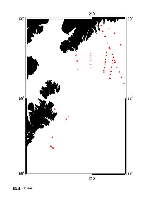
Chart of Mooring Locations: