|
| |
||||||||||||||||
Teacher Logbook - R/V Wecoma Missy
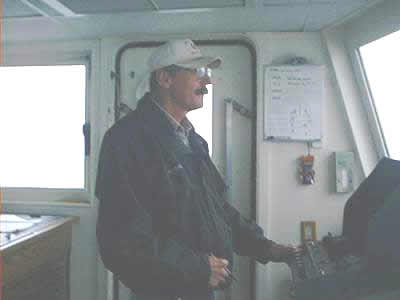
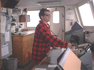
Holzer 's Sealog: Today finds us in the midst of a tow-yo after about 6 hours of steaming to our new location - the Cleft segment of the Juan de Fuca Ridge. Keeping the R/V Wecoma in a straight path during a tow depends on the expertise of the crew at the helm where they employ state of the art technology in maintaining an accurate position while the NeMO CTD cruise is underway. Whether it's the Captain, the 2nd Mate, or the Chief Mate, the crewmember at the helm takes full charge of the ship while on they are on their watch. At the helm, safe navigation is their first objective along with the safety of the vessel and the crew. Captain Dan Arnsdorf works closely to ensure that the Chief Scientist meets his/her science objectives while on the ship by controlling and maintaining the position of the ship while the science is being performed. Maintaining the position of a ship in this vast expanse we're sailing in has changed over time: from the use of celestial navigation (the use of the position of celestial objects to find a position on land), to the use of signals sent to land and back to sea, to the current use of GPS (Global Positioning System). Since the onset of GPS, the ship always knows where it's at, whereas before GPS, the confirmation of a position was determined after receiving a signal from the shore sometimes just 4 times a day. To aid those at the helm even further, computer charting programs that work in conjunction with GPS plot the ship's course and helps it maintain its position with accuracy to 3 decimal places in latitude and longitude. This is an asset to a scientist like Dr. Baker who relies on accuracy in the ship's position to aid his work in locating hydrothermal activity. The use of technology in navigation doesn't mean that those wanting to take the helm don't have to learn how use the position of the stars and sun to navigate the ocean waters. On the contrary, proficiency in celestial navigation is necessary should the unfortunate need arise where it's the only method to guide a ship to safety. The Captain or whoever else has the helm is the first person notified of any activity on the ship where safety is involved. When the "fish" is deployed or if the door to the fantail needs to remain open while instruments are moved in and out of the ship, permission must be acquired from the Bridge first, and at the conclusion of the activity, the Bridge must notified again. Rough seas can be detrimental to oceanographic equipment, especially while deploying and recovering, so the Captain and the Chief Scientist are constantly dialoguing to ensure that safety is maintained at all costs, even if means postponing a cast or tow-yo until the waters are calmer. Fortunately for the NeMO CTD Cruise the summer waters in this area are usually the calmest of the year, and fortunate for the crew and staff on board, we are under the watchful eyes of those at the helm of the R/V Wecoma. |
|||||
| NeMO Home |About NeMO | Expeditions | NeMO Net | Explore | Dive! | Education |