|
| |
||||||||||||||||
Teacher Logbook - R/V Wecoma Missy
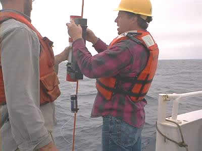
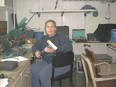
Holzer 's Sealog: What kind of hydrothermal activity can be expected over the next year? That's a question the science crew has set out to explore as they continue their quest to extend their data set into the future. Over the past couple of days a number of moorings with computer operated instruments (MAPR's, MTR's etc.) were deployed in the Axial volcano area. The instruments have been calibrated and set to gather data from the water column every 30 minutes for the next year. Data acquisition in oceanography has changed immensely over the years from towing instruments from the back of a ship to computer operated instruments that can not only explore the water column over time, but can also roam the ocean floor. Someone who has seen a few of these changes over her career is oceanographer Sharon Walker. Ms. Walker began her career with Dr. Baker's Hydrothermal Plume Studies Group over 20 years ago as an undergraduate student, although they weren't studying hydrothermal plumes at the time. When she started, the focus of the study was the mass distribution of transported particles in the Puget Sound and Bering Sea areas, and since 1984-1985 the focus shifted to hydrothermal vents. Although she has always used automated instrumentation in her studies, now her responsibilities have shifted to being responsible for writing the software that runs the automated instruments. The engineering department at the PMEL NOAA lab developed the MAPR's, while Ms. Walker developed the software so that a desktop computer can communicate with the instruments before they are deployed and after they are recovered. Once the instruments are recovered they can be connected to a PC and the data from the past year can be displayed on the screen in a format that is friendly to the user. The MAPR is such a compact instrument (about 40cm long) and the software so easy to use that it has gone on other expeditions outside the hydrothermal study group. MAPR's have been to the Arctic, Indian Ocean, New Zealand, South Pacific, etc., and have rode piggyback to instruments employed for other scientific research, and brought back interesting water column data for the hydrothermal group. If the instruments are gathering data every 30 minutes for a year, there is quite a bit of data to be managed. Ms. Walker has the responsibility of data acquisition and data management, and she does so by using a variety of forms and filing systems. Her work isn't complete once the data is filed; she also combines different data sets to create graphical displays of the data. For example, Ms. Walker combines the navigation data with the CTD data to produce a pictorial representation of what the ocean column looks like in the area under study. Being the computer programmer in the group has brought Ms. Walker the enjoyable challenge of being the troubleshooter in the group; if software is needed, she can develop a program. Organizing equipment for cruises is another one of the many tasks that Ms. Walker undertakes at the PMEL NOAA lab. Lists and systems have been developed to facilitate the preparations for the cruise, so preparing for the scheduled cruises has almost become a routine event. What happens when the hydrophones near the plate boundaries signal that seismic activity is occurring near one of the ridges? The "response cruise" must be ready in 7 to 10 days to cruise out to the site and survey the area for hydrothermal activity. The test for the response cruise came in April 2001 when the word was out that there was seismic activity in the Gorda Ridge area of the Juan de Fuca Ridge. The ship was secured and the equipment loaded within 7 days. This was a satisfying feat for Ms. Walker and the Hydrothermal Plume Study Group. Ms. Walker is happy to be in this program since she finds a lot interest and enjoyment in what she does. She is a valuable contributor to the progress of the group, and they are fortunate to have her experience and dedication adding to their efforts. |
|||||
| NeMO Home |About NeMO | Expeditions | NeMO Net | Explore | Dive! | Education |