|
| |
||||||||||||||||
|
|||||||||||||||||||||||||||||||||||||||||||||||||||||
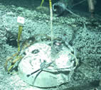
 Bridge formed in 1998 lava flow from an area of fast draining, and collapsed lava. (click image for larger view) |
We have now finished six days of operations at Axial Seamount and are transiting NNE to our third and last dive site, the Cobb segment, where we will explore a little known part of the Juan de Fuca Ridge. The days we spent at Axial were chock full of activity, both on the ship and on the seafloor. As part of our NeMO seafloor observatory, we are trying to monitor Axial volcano to learn about its eruption cycle. It last erupted in 1998 and we know it is building towards its next one, but we don’t know exactly when that will be. We hope that after we study one eruption cycle we will learn what to expect in future cycles. Our monitoring instruments include Ocean Bottom Hydrophones (OBHs - which detect earthquakes), Bottom Pressure Recorders (BPRs - which measure uplift and subsidence of the seafloor), and Remote Access Samplers (RAS - which can take a sample every week for a year from a hydrothermal vent). All of these instruments can operate on the seafloor for 1-2 years and while we are out here we recover them, download their recorded data, replace batteries, and redeploy them. These instruments help us know what is happening at Axial when we are not here with a ship. We also repeat Conductivity, Temperature, and Depth (CTD) casts in selected sites to get a view of the hydrothermal plumes over the vent sites from year to year. All these operations are done on board with the help of the ship’s crew.
In addition, we used both the MBARI autonomous underwater vehicle (AUV) and the JASON remotely operated vehicle (ROV) to explore parts of the caldera floor that we have never visited at Axial volcano. The AUV and the ROV are a perfect combination, because the AUV gives us bathymetric maps with such incredible detail that we can actually see features that are at the same scale as the things we can see with the ROV’s video and lights. This allows us to interpret what we see during an ROV dive in the broader context of the AUV map. We can also plan ROV dives that go to interesting or confusing features on the AUV map, and usually seeing them with the ROV’s video cameras helps us interpret them. The dives we made using this powerful combination of technology were a particular highlight for me this year. We found that some truly enormous eruptions have occurred in the past within the caldera.
Another highlight has been the use of a high-definition (HDTV) camera on Jason during our dives this year (as a pilot project supported by the NOAA Ocean Exploration Program and Woods Hole Oceanographic Institution). While the video and images recorded by the HDTV camera will have to be post-processed after the cruise to reach their full potential, the images we have seen at sea are stunning in their clarity and color. We will be posting selected images and video from the HDTV camera after the cruise.
.
|
Sep/Oct 2004
| ||||||
| S | M | T | W | T | F | S |
| 12 | 13 | 14 | 15 | 16 | 17 | 18 |
| 19 | 20 | 21 | 23 | 24 | 25 | |
| 26 | 27 | 28 | 29 | 30 | 1 | 2 |
Today's Events:
CTD Tow at southern Cobb Segment.
Jason dive J2-294 discovers 2 active hydrothermal sites at Cobb.
|
Today's
photos |
|
click
caption for larger view |
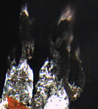 El Guapo vent with torch-like chimneys. |
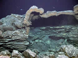
 Tubeworms at the CASM vent field. |
| NeMO Home |About NeMO | Expeditions | NeMO Net | Explore | Dive! | Education |