Contour-profile
instructions - page 1
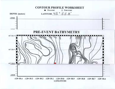
Each group should start with the PRE-event map and a black pencil. Notice that each contour on the map has a label with the depth in meters. Depths are also listed on the y-axis of the contour profile worksheet. To show how to make a profile, we will use profile #3 along 45° 55.8' of latitude as an example. Begin by folding the PRE-event bathymetric map along the 45° 55.8' latitude line. Keep the map folded on this line of latitude while you work on this profile. Line up the margins of the map and the worksheet.
Version
2.0 


 page
43 of 55
page
43 of 55