Bathymetric
Map
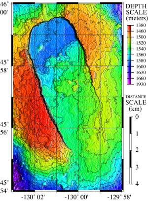
Color bathymetric map of Axial caldera
(blue is deepest, red is shallowest).
Version
2.0 


 page
12 of 55
page
12 of 55
|
Bathymetric
Map
|
|
|
Color bathymetric map of Axial caldera (blue is deepest, red is shallowest). |
On the following page you will find a large format black and white bathymetric map of the summit caldera of Axial Volcano. The black squiggly lines are contours of equal depth (at a 10 meter interval). Print it out to use as a worksheet for the triangulation activity. It can also be enlarged and printed on 11" x 17" plain paper. |
|
Version
2.0
|
|