|
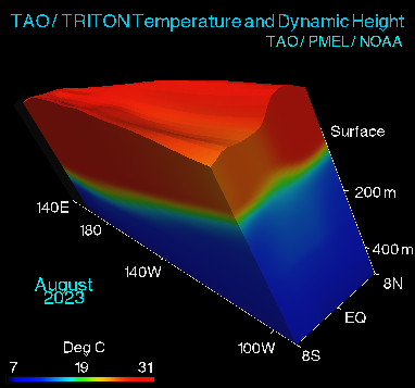
This is a view of the current El Nino / La Nina evolving in the tropical
Pacific Ocean. You are looking westward, across the equator in
the Pacific Ocean, from a vantage point somewhere in the Andes
Mountains in South America.
The colored surfaces show TAO/TRITON ocean temperatures. The top surface
is the sea-surface, from 8°N to 8°S and from 137°E to
95°W. The shape of the sea surface is determined by TAO/TRITON Dynamic
Height data. The wide vertical surface is at 8°S and extends
to 500 meters depth. The narrower vertical surface is at 95°W.
The animation frames show monthly values for
the last 60 months. All of these data come from the TAO/TRITON
Array of moored ocean buoys in Equatorial Pacific.
|