Feature Publication Archive
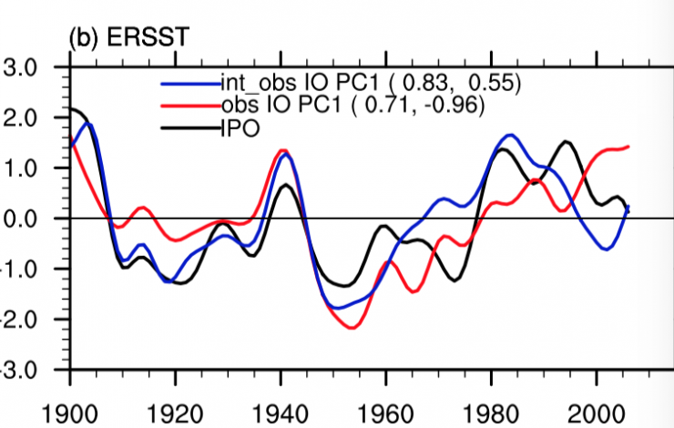
Time series of the Inter-decadal Pacific Oscillation (IPO, black lines), the decadal Indian Ocean Basin mode (IOB, red lines), and internal component of the decadal IOB mode with external forcing (obtained from ensemble mean of three all forcing runs based on CESM1.2) removed (blue lines) from ERSST. All the time series are standardized. The correlation coefficients with the IPO during 1900–2012 and 1985–2012, respectively, are shown in parentheses.
Dong, L., and M.J. McPhaden (2017): Why has the relationship between Indian and Pacific Ocean decadal variability changed in recent decades? J. Climate, 30(6), 1971–1983, doi: 10.1175/JCLI-D-16-0313.1.
Lu Dong and Michael McPhaden's recently published paper in the Journal of Climate is featured as a Research Highlight by Nature Climate Change on April 5, 2017. The paper analyzes why the relationship between the decadal Indian Ocean Basin (IOB) mode and Interdecadal Pacific Oscillation (IPO) has changed in recent decades. “Historically, patterns of decadal sea-surface temperature (SST) variability in the Indian and Pacific Oceans... more »
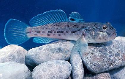
The Eurasian Round Goby Neogobius melanostomus. Photo credit: Dr. David Jude
Snyder, M.R., and C.A. Stepien (2017): Genetic patterns across an invasion's history: A test of change vs. stasis for the Eurasian round goby in North America. Mol. Ecol., 26, 1075–1090. doi:10.1111/mec.13997.
Invasive species are one of the world’s most serious environmental problems, ranking as the second most serious cause to biodiversity declines (next to habitat loss). Key U.S. aquatic systems—including the Great Lakes, San Francisco Bay, and Chesapeake Bay—have been subjected to ongoing onslaught by invasive species that are accidentally introduced from foreign ports via shipping. Several of these cause severe industrial fouling, alter ecosystem structure and functions, and change food web relationships, resulting in significant economic loss.
From the standpoint of the invasive... more »
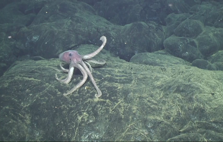
A deep-sea octopus explores the brand-new lava flows erupted at Axial Seamount in 2015. At the time, this was probably the youngest seafloor on the planet. Photo Credit: Bill Chadwick, Oregon State University/PMEL, and ROV Jason, Woods Hole Oceanographic Institution
Chadwick, Jr., W.W., B.P. Paduan, D.A. Clague, B.M. Dreyer, S.G. Merle, A.M. Bobbitt, D.W. Caress, B.T. Philip, D.S. Kelley, and S.L. Nooner (2016): Voluminous eruption from a zoned magma body after an increase in supply rate at Axial Seamount. Geophys. Res. Lett., 43 (23), 12,063–12,070, doi:10.1002/2016GL071327.
Nooner, S.L., and W.W. Chadwick, Jr. (2016): Inflation-predictable behavior and co-eruption deformation at Axial Seamount. Science, 354 (6318), 1399–1403, doi:10.1126/science.aah4666.
Wilcock, W.S.D., M. Tolstoy, F. Waldhauser, C. Garcia, Y.J. Tan, D.R. Bohnenstiehl, J. Caplan-Auerback, R.P. Dziak, A.F. Arnulf, and M.E. Mann (2016): The 2015 eruption of Axial Seamount: Seismic constraints on caldera dynamics. Science, 354 (6318), 1395–1399, doi:10.1126/science.aah5563.
Axial Seamount, 300 miles off the coast of Oregon and 0.7 miles beneath the ocean’s surface, is situated along a mid-ocean ridge where two ocean plates are moving apart. It is the most active submarine volcano in the northeast Pacific Ocean, with documented eruptions in 1998, 2011, and most recently, in 2015. Its activity has been monitored for two decades, since the establishment of the NeMO Seafloor Observatory in 1996, and more recently the launch of the National Science Foundation’s Ocean Observatories Initiative Cabled Array, which provides state-of-the-art monitoring capability with... more »
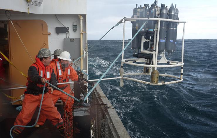
NOAA Ship Oscar Dyson crew retrieve a CTD (Conductivity, Temperature and Depth) in the Eastern Bering Sea during an Ecosystems and Fisheries-Oceanography Coordinated Investigations (EcoFOCI) cruise.
Van Pelt, T.I., J.M. Napp, C.J. Ashjan, H.R. Harvey, M.W. Lomas, M.F. Sigler, and P.J. Stabeno (2016): An introduction and overview of the Bering Sea Project: Volume IV. Deep-Sea Res. II, 134, 3–12, doi:10.1016/j.dsr2.2016.09.002.
“…the National Science Foundation (NSF) and the North Pacific Research Board (NPRB) created a novel partnership in 2007 to support an ecosystem-scale study to examine how a changing climate and changing sea-ice conditions affect the EBS ecosystem, from physics and chemistry to lower trophic level organisms (e.g., plankton) to humans. The “Bering Sea Project” integrated two major research programs, the NSF-funded Bering Ecosystem Study (BEST) and the NPRB-funded Bering Sea Integrated Ecosystem Research Program (BSIERP... more »
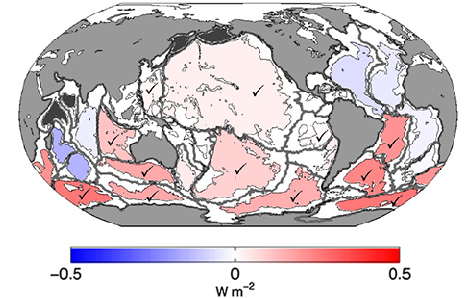
Basin-averaged 1991–2010 warming rates (expressed in W m-2, see colorbar) for the abyssal ocean (4000–6000 m) estimated using data from repeated high-quality, full-depth, coast-to-coast global surveys of ocean water properties. Check marks indicate basins in which warming rates are statistically significantly different from zero
Desbruyères, D.G., S.G. Purkey, E.L. McDonagh, G.C. Johnson, and B.A. King (2016): Deep and abyssal ocean warming from 35 years of repeat hydrography. Geophys. Res. Lett., 43, 10356–10365, doi:10.1002/2016GL070413.
Decadal repeats of high-quality, full-depth, coast-to-coast global surveys of ocean water properties have been revisited since the 1980s. These surveys were completed first under the auspices of the World Ocean Circulation Experiment, then CLIVAR/CO2, and now GO-SHIP. The data from these surveys provide global ocean observations below the 2000-meter sampling limit of core Argo floats. Evaluation of deep warming trends below 2000 m using these highly accurate (±0.002°C) survey data yields an estimate of a net heating rate of 33 ± 20 TW (1 TW = 1,000,000,000,000 Watts) from 1991 to 2010,... more »