FISHERIES and the ENVIRONMENT:

Multi-decadal simulations of circulation and walleye pollock in the Coastal Gulf of Alaska


Principal Investigators/Laboratories: Albert J. Hermann, Pacific Marine Environmental Laboratory, Seattle, Washington; Martin Dorn, Alaska Fisheries Science Center, Seattle, Washington; Sarah Hinckley, Alaska Fisheries Science Center, Seattle, Washington


Background

Walleye Pollock, Theragra Chalcogramma, have been observed to spawn in large numbers within Shelikof Strait since at least 1978. In 2000-2002, spawning populations of pollock declined markedly in Shelikof Strait. It has been hypothesized that this decline was related to broad-scale changes in the circulation and temperature fields; e.g. the return of the Pacific Decadal Oscillation index to a pre-1976 (“cold”) phase. To explore interannual variability of circulation and recruitment, the Fisheries Oceanography Coordinated Investigations (FOCI) program implemented the  Semispectral Primitive Equation Model (SPEM) of Haidvogel et al. (J. Comput. Phys., 1991). Output from this model has been coupled to a lower trophic level (NPZ) model, and an individual-based model (IBM) which uses the NPZ output for spatially explicit prey fields. However, existing circulation hindcasts (for March-September of years 1978-1999) were not adequate temporally or spatially to resolve questions regarding the potential influence of shifts in circulation on the migratory behavior of spawning pollock. Much longer hindcasts of the physical and biological dynamics, including the winter months, and much broader spatial coverage, are required to properly address the issue of interdecadal variability in pollock spawning and recruitment. These hindcasts will help address interdecadal variability in growth and migration of many other fish species (e.g. salmon), as well.

Circulation Results and Indices

A set of spatially nested models are being used for these improved hindcasts, based on the Regional Ocean Modeling System (ROMS; Haidvogel et al., Dyn. Atmos. Oceans, 2001), and developed with our colleagues in the Global Ecosystems Dynamics (GLOBEC) program. Nested models include the Northeast Pacific at ~10 km resolution (NEP model, driven with NCEP winds) and the Coastal Gulf of Alaska at ~3 km resolution (CGOA model, driven with finer-scale MM5 winds). Sample output (with Sea Surface Height) is shown in Figure 1:

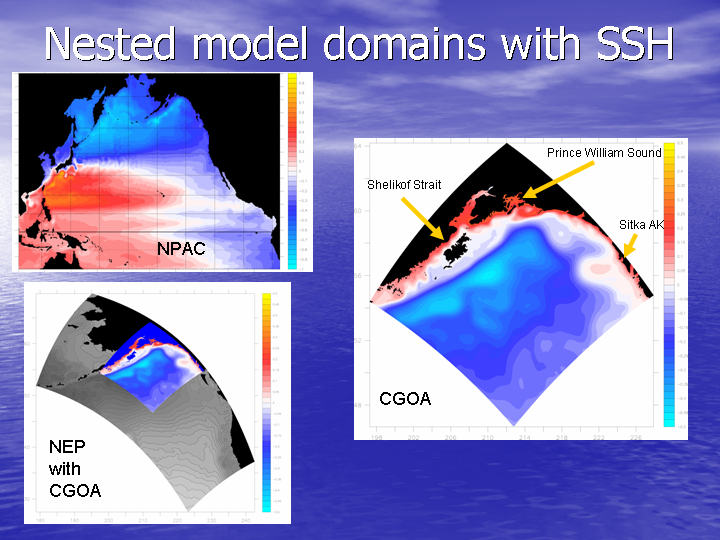
Figure 1. Sea surface height (m) from runs of three spatially nested models: North Pacific (NPac), Northest Pacific (NEP) and Coastal Gulf of Alaska (CGOA). SSH of NEP results are shown in greyscale (lighter color denotes higher SSH).


Thus far we have completed a 6-year (1996-2002) hindcast of circulation with the NEP model.  Analysis of coastal sea level output indicates the 97/98 El Nino and a 98/99 regime shift are captured by 
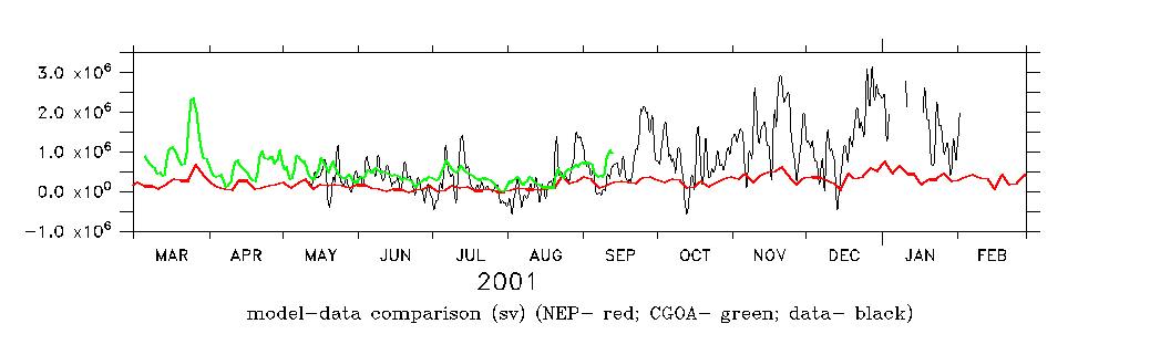
this simulation. Velocity output from the NEP model has been compared with current meter data in Shelikof Strait (Figure 2). Results from NEP are found to be well correlated with this data (rsquared = .65), but smaller in amplitude. The CGOA model yields a much closer match to the absolute magnitudes observed in 2001.

Figure 2. Model results showing depth-integrated flux through Shelikof Strait (m3/s). Top figure shows results from NEP model driven with NCEP winds. Bottom figure shows observed flow through Shelikof Strait from current meter moorings (black line, from Stabeno et al, unpublished) with model results: NEP model driven by NCEP winds (red line) and CGOA model driven by MM5 winds (green line).

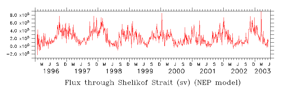
The multiyear results from the NEP model were regressed on the observed flux derived from current meter moorings, to yield the following multiyear index of flux through Shelikof Strait (Figure 3):

estimated flux through Shelikof Strait
Figure 3. Model-based index of flux through Shelikof Strait (m3/s). Click here for an asci listing of this index


Biological Results and Indices

Thus far we have produced NPZ hindcasts of year 2001 using the CGOA circulation model with an embedded salmon NPZ model (that is,one structured to generate salmon prey items).  Results for phytoplankton and zooplankton have been compared with SeaWifs ocean color and in situ data, and found to produce the appropriate seasonal and onshore-offshore patterns. Results from the CGOA biophysical model are posted and available for interactive browsing on our implemetation of the Live Access Server.


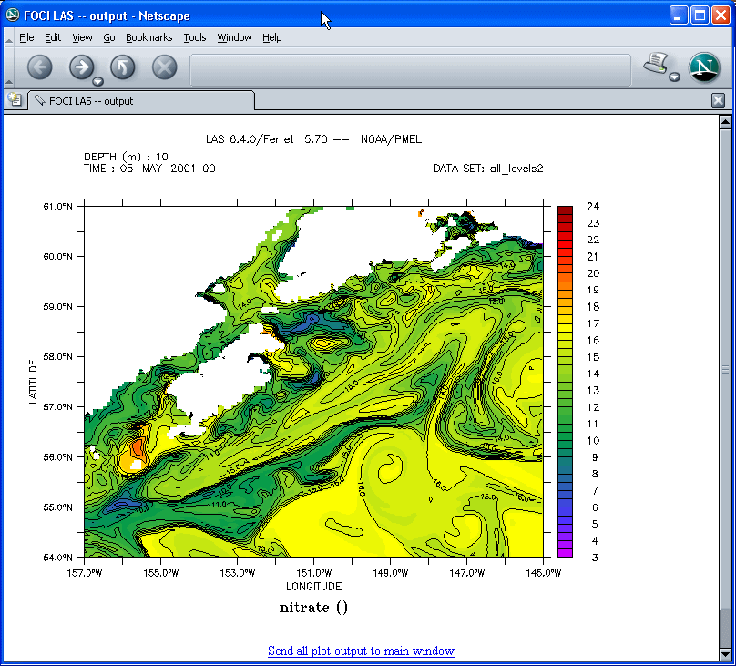
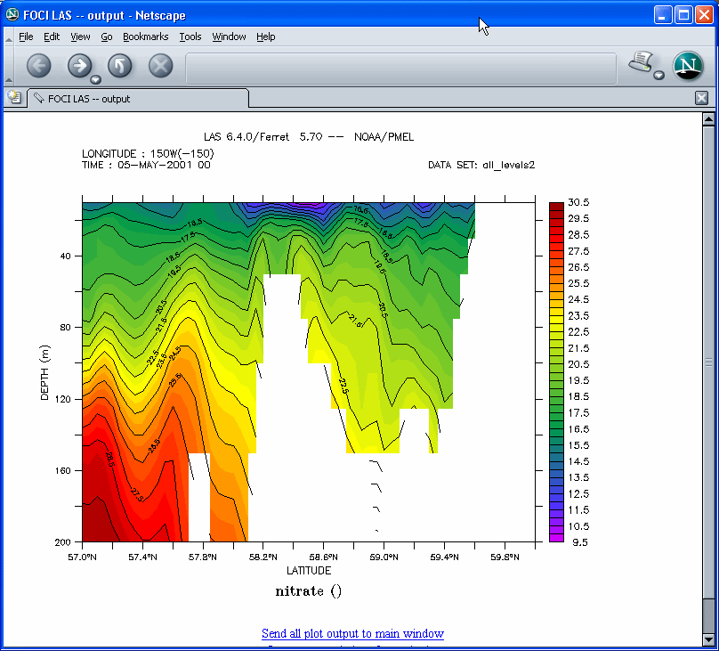
The CGOA model resolves strong mixing over tidal banks near Shelikof Strait, and illuminates many of the important details of vertical and cross-shelf nutrient transport not resolvable in the previous FOCI biophysical models. Horizontal and vertical sections from our FATE Live Access Server are shown below. In particular, we have discovered an unanticipated broad upwelling of nutrients over the shelf upstream of Kodiak Island in the spring. As intended, the new models have significantly extended the domain of the earlier models, while enhancing the resolution of crucial vertical and horizontal structure.


To GLOBEC NEP modeling overview

HOME
Contents last updated Thu, 13 Oct 2004 17:11:14 GMT
Al Hermann - albert.j.hermann@noaa.gov