WHAT'S NEW:
BACKGROUND:
Mission
Project Description
Cruise Plans:
Participants
Technology (ROV, ships, etc.)
Future Plans
Results:
1998 NeMO Cruise
Axial 1998 "Eruption"
Logbook
July 7, 1999
July 7, 1999
Contents:
- News from Thompson
- Participant Perspective
- Logbook from Teacher at Sea
- Question/Answer from shore to sea
Thompson Science Report
Science Report - Wednesday, July 7
Ships Location: 46 00.9/130 01.5
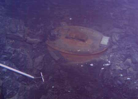
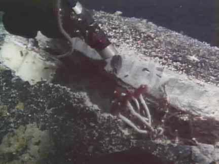
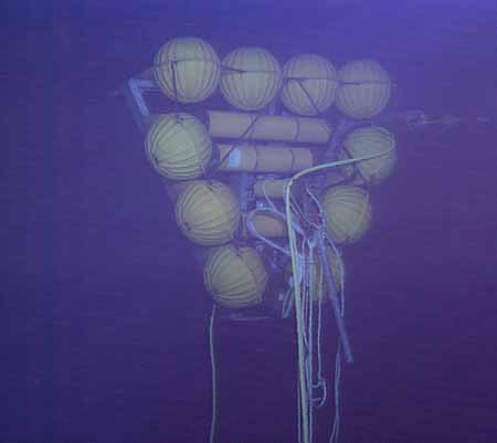
ROPOS collected Imagenex data all night as dive 496 continued into the morning when it cut the anchor line holding down the rumbleometer.
Rumbleometer safely on deck of the Thompson after surviving a lava flow. |
 Slight melting of the Rumbleometer's floatation. |
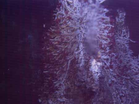
This evening, ROPOS went back in the water for dive 497, this time on Axial's north rift zone to recover and deploy acoustic extensometer instruments with the elevator, and then to visit CASM, a high-temperature vent site at the northern end of the caldera, for biological and slurp sampling and to recover temperature probes deployed there last year.
Listing of all Science News postings
Life at Sea: Participant Perspective
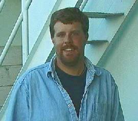
Paul Johnson
University of Hawaii
 Aloha from the
North East Pacific Ocean. The first thing I must admit is that the cold
grey Pacific ocean which we are currently working in is quite a change
from the warm blue Pacific waters around Honolulu, Hawaii where I live.
I work as a marine geologist for the
Hawaii Mapping Research Group (HMRG) at the University of Hawaii.
HMRG specializes in the both the science and engineering behind designing,
building, running, and interpretation of data of systems that map the
ocean floor. My job at HMRG, whether we are working at the University
or out somewhere at sea, is to process the data from these system and
to then generate maps from this data.
Aloha from the
North East Pacific Ocean. The first thing I must admit is that the cold
grey Pacific ocean which we are currently working in is quite a change
from the warm blue Pacific waters around Honolulu, Hawaii where I live.
I work as a marine geologist for the
Hawaii Mapping Research Group (HMRG) at the University of Hawaii.
HMRG specializes in the both the science and engineering behind designing,
building, running, and interpretation of data of systems that map the
ocean floor. My job at HMRG, whether we are working at the University
or out somewhere at sea, is to process the data from these system and
to then generate maps from this data.
Before working at HMRG I worked for the Dr. Embley and Dr. Chadwick in Newport, Oregon as a Research Assistant doing work on the Juan de Fuca Ridge. So when they asked me if I wanted to come along, I jumped at the chance. I was especially intrigued about the opportunity of being able to do a comparison of the Hawaiian style volcanic features, which I have had the pleasure to watch form as the molten rock was erupted out of the earth, and the types of features we would find during our dives on this cruise.
My role on this cruise is as one of the three navigators. Using a network of transponders set out on the seafloor we are able to determine the location of ROPOS as it moves along the seafloor. We monitor the ROV's movement, determine the quality of the navigation that we are collecting, and relay information to both the ROPOS team and the bridge of the ship on where different vents or features are located. This turns out to be a pretty interesting role as you are involved with the some of the operations of the dive, instead of just being an observer. However, no matter how interesting it is, getting up for my first shift of the day at 3:30am is sometimes just a little bit too painful.
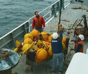
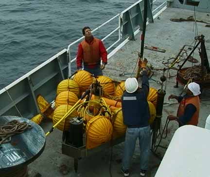
Today actually proved to be a very exciting days for me personally as I was involved with the small boat recovery of the rumbleometer which we freed from grips of the lava flow last night. If you have ever seen a small boat launch from a ship of this size, you would know that it is a pretty neat sight. You get into the boat on the level 2 deck of the ship, the boat then drops on a harness and descends something like 30 feet to the water below, where you then start up the engines and take off......pretty cool. Once on the water we had a spectacular view of the R/V Thompson with nothing but the Pacific around it (why, oh why, did I forget my camera). Our job in the small boat was to remove all of the loose lines and gear from the rumbleometer (after it made it to the surface), so that after we towed it back to the ship it would make pulling it out a whole lot easier. This turned out to be quite a bit of work as all of the lines were crossed and fouled on the top of the rumbleometer. After some pretty hard work of yanking and tugging on lines we had almost all of the lines either off the rumbleometer or secured. The rumbleometer was then lifted up on the deck of the ship using the crane, and we then zoomed in next to the ship and the entire small boat was picked up by the harness and hauled back up. All in all, a pretty great day.
Listing of all Perspectives postings
Teacher At Sea Logbook
Thompson Teacher at Sea Log Teachers log #17 7/7/99
 What a morning! Under gray skies and calm seas, ROPOS successfully cut
the anchor tether line holding the recently
released rumbleometer from its 20 month stay on the seafloor. While
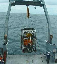
it slowly floated to the surface, ROPOS was brought aboard (photo left).
The small recovery boat successfully collected the rumbleometer and towed
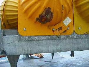
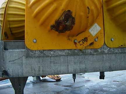
it to the Thompson. After it was secured on deck it was examined and we
noticed that small areas of melting
were visible on the yellow plastic floats and some had lava fragments
embedded in them. Chief
Scientist Bob Embley and staff began removing the instrumentation
following their inspection. The seismic data collected will be fully analyzed
back on shore. Dive 496 included some biological sampling and Imagenex
surveying in addition to the rumbleometer recovery and was a huge
success.
What a morning! Under gray skies and calm seas, ROPOS successfully cut
the anchor tether line holding the recently
released rumbleometer from its 20 month stay on the seafloor. While
it slowly floated to the surface, ROPOS was brought aboard (photo left).
The small recovery boat successfully collected the rumbleometer and towed
it to the Thompson. After it was secured on deck it was examined and we
noticed that small areas of melting
were visible on the yellow plastic floats and some had lava fragments
embedded in them. Chief
Scientist Bob Embley and staff began removing the instrumentation
following their inspection. The seismic data collected will be fully analyzed
back on shore. Dive 496 included some biological sampling and Imagenex
surveying in addition to the rumbleometer recovery and was a huge
success.
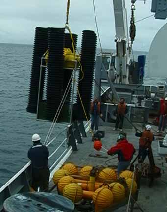
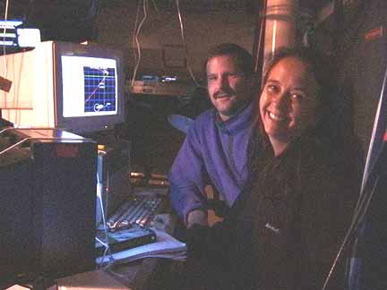
ROPOS is being prepared for another complicated dive along the North Rift Zone and a vent called CASM. Dr. Bill Chadwick is planning to deploy one new extensometer (photo right) and retrieve four that were left at this site last year.
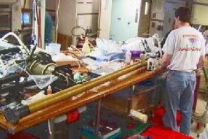
Bill Chadwick preparing the extensometer's electronics for deployment. |
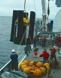
The extensometer inside the elevator preparing for deployment |
Remember that when using the elevator we need to have calm seas and good weather, so keep your fingers crossed. Dive 497 is on its way to the bottom now to deal with the extensometers. Stay tuned for an update tomorrow.
Bye for now.
Logbook of all Teacher At Sea postings
Questions & Answers
(oar.pmel.vents.webmaster@noaa.gov)