
|
|
|
||||||||||||||
| Welcome | ||||
|
Visit
the latest NeMO Net site:
|
NeMO Net 2001 was deployed on July 27 with ROPOS. Instruments include 2 temperature probes and a Remote Access Sampler for obtaining chemical samples. The 2001 system stopped transmitting data on August 5 due to failure of the bottom-mounted acoustic modem. However, sampling should proceed weekly and data will be analyzed when the system is recovered in 2002. |
|||
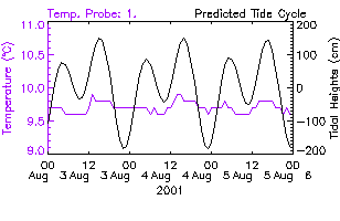
| Temperature data | ||||
|
|
Temperature was measured once an hour by both probes. Every 24 hours the resulting 72 temperature measurements were transmitted to the laboratory. Tides were displayed for comparison. |
|||
| Chemical sensors | ||||
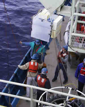
| Sampler system test deployment image |  In
July, 2001, a time-series sampler capable of collecting vent fluid and particles
directly from a seafloor vent was installed. The core of this system is
the McLane 48-500 Remote Access Sampler, with hardware and software enhancements
done at PMEL. Measurements of pH and H2S will be monitored
daily. The sampler will be programmed to take a water/particle sample once
per week and collect chemical sensor data twice per week. In
July, 2001, a time-series sampler capable of collecting vent fluid and particles
directly from a seafloor vent was installed. The core of this system is
the McLane 48-500 Remote Access Sampler, with hardware and software enhancements
done at PMEL. Measurements of pH and H2S will be monitored
daily. The sampler will be programmed to take a water/particle sample once
per week and collect chemical sensor data twice per week. |
|||
| Background | ||||
| NeMO Home |About NeMO | Expeditions | NeMO Net | Explore | Dive! | Education |