WHAT'S NEW:
Eruption Confirmed!
New lava (rumbleometer stuck in flow) SE rift zone
(posted 9/1/98)
BACKGROUND:
Technology (ROV, ships, etc.)
Other 1998 Axial cruise reports
EXPEDITION:
Science Objectives
Calendar
Today's Science News
Participant Perspective
Teacher Logbook
EDUCATION:
Curriculum
Teacher Observations
Questions/Answers from sea
MULTIMEDIA:
(video clips, animations, sounds)
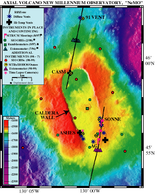
Bathymetric map of the NeMO Observatory at Axial Volcano. Depths are color-coded from red=shallow to purple=deep (depths in meters by color are shown on the legend in the lower left). Hydrothermal vent locations are indicated with large crosses (high-temperature) and blue stars (diffuse-low temperature); major vent fields are Ashes, Casm, Axial Gardens (AG) and Sonne. Stippled black lines represent north and south rift zones.
Other symbols represent scientific instrumentation in place or planned for future deployment.
Instrument abbreviations:
MTR/CM: Current meter moorings to detect water flow direction at depth
SIO OBH: Scripps Institution of Oceanography's Ocean Bottom Hydrophones to detect small earthquakes
Rumbleometers: bottom mounted instrument to detect earthquakes and ground tilt
Extensometer: array of instrument to detect plate movement/stretching
HOBOS: high temperature probes to detect long term changes in temperature
Osmos: time-series information gatherer of changes in seawater
Time Lapse Camera: long-term deployed camera to image changes on seafloor