WHAT'S NEW:
Other 1998 Axial Cruise Reports
(posted 8/13/98)
BACKGROUND:
Technology (ROV, ships, etc.)
Other 1998 Axial cruise reports
EXPEDITION:
Science Objectives
Calendar
Today's Science News
Participant Perspective
Teacher Logbook
EDUCATION:
Curriculum
Teacher Observations
Questions/Answers from sea
MULTIMEDIA:
(video clips, animations, sounds)
Logbook
August 27, 1998
August 27, 1998
Contents:
Science Report
Science summary for mid-day Aug 26 to mid-day Aug 27
Once the ship gets to a dive site, (and even before all of us have our "sea legs") one of the first task is usually to deploy "acoustic transponders" so that we can locate the ROV underwater. This is an important first step in our work because, while the ship can know where it is at all times from satellite positioning, those satellite signals cannot penetrate through water. So we must keep track of ROPOS underwater with sound.
Transponders are acoustic beacons that "ping" underwater at different frequencies. We first drop them from the ship, then located them precisely, and once that is done we can locate anything else underwater relative to those transponders. This process takes about a day. For example, we deployed and precisely located 11 transponders in 3 separate locations over the last 20 hours. During a dive, the ROV pings to all the transponders and they ping back to it and the round trip travel times tell us how far the ROV is from each of the transponders with an accuracy of 1-2 meters (3-6 feet). Pretty good considering the ROV is almost a mile underwater!
This precise navigation is critical to many of the things we will be doing during the cruise, such as finding and returning to specific vent sites, locating the samples we take on the bottom, conducting site surveys, and of course placing all our new observations in the context of previous work at Axial. Knowing where you are is something we take for granted on land, because we can *see* our surroundings. But on the bottom of the ocean, it is pitch black, and it is amazingly easy to get lost and disoriented without the help of good navigation. Even with the lights that ROPOS has and the cameras that feed live video up to the ship, we can only see about 15-30 feet in any direction. That would be like exploring the dark side of the moon with a flash light. Everything is always much easier when you know where you are, where you've been, and where you are going at all times. That's why we invest this time at the beginning of these kinds of expeditions.
|
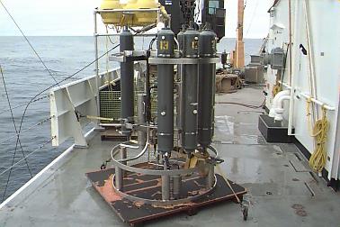
After the calibration, a CTD cast was conducted. Now we're ready to dive! NOAA CTD "rosette" on deck of Brown 8/26/98
|
|
1:45 AM
ROPOS was on the bottom at 11pm (PST), in the SE caldera area. Seeing massive amounts of floc (see video of floc/bacterial mats from CoAxial site 1993) in the water and lots of bacterial mats. The dive is in progress. A more detailed science report about the dive will follow tomorrow.
Listing of all Science News postings
Life at Sea: Participant Perspective
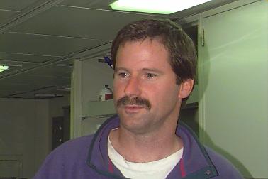
Hi. My name is Bill Chadwick and I am a geologist who studies volcanoes. I've worked on volcanoes on land like Mount St. Helens and Kilauea in Hawaii, but for the last 9 years I've been studying the volcanoes on the bottom of the ocean. That might seem like a funny place to study volcanoes, but it turns out that about 75% of the Earth's volcanic activity takes place on the ocean floor. This is because the Earth has a system of mid-ocean ridges all aroundit and in every ocean, and these ridges are places where tectonic plates are moving apart. As the plates spread, magma (molten rock from deep inside the Earth) moves up to fill the gap and some of it erupts on the seafloor as new lava flows. Geologist have known for many years that many eruptions must be taking place on the mid-ocean ridges every year, but before about 5 years ago no one had any idea when and where - there was no way to detect them. About 6 years ago, the technology was developed to detect seafloor eruptions as they are happening and since then we have detected 3 eruptions in the NE Pacific, one of which was this past January at Axial volcano, where we are now.
All of this makes the work I do very interesting and exciting, because it really feels like discovery. We know so little about mid-ocean ridge volcanoes and how they work that almost every thing we see and learn seems brand new. It is an incredible research opportunity for all of us, and it's fun to be figuring things out for the first time.
In my own research, I like to study the "active" and "dramatic" things that the Earth does - like when it erupts lava or when faults move during earthquakes. Some of the specific work I'll be doing on this cruise will be searching for where new lava might have come out during the January earthquake swarm. We still do not know *for sure* that lava erupted, but we think it did and we have some ideas of where to look for it with ROPOS. Tune in later to see if we find it! Another project will be recovering some instruments called "acoustic extensometers" with ROPOS that we deployed on the north rift zone of Axial in 1996, part of an experiment to measure actual "seafloor spreading" during volcanic events like the one that occurred in January. Pretty good timing, huh? I hope they worked! Another thing I'll be doing is conducting surveys with an instrument called an Imagenex scanning sonar mounted on ROPOS. This sonar can be used to make very detailed maps of small areas and we think that this will help us understand why hydrothermal vents occur where they do, and how they are related to the geology of Axial volcano. Thanks for your interest in our expedition and we're looking forward to sharing with you some of the excitement of that feeling of discovery.
(I also want to say "I miss you" to my 5-year old daughter Kelly who was crying her eyes out when daddy left Newport on the ship a few days ago one of the hardest parts of oceanography!)
Listing of all Perspectives postings
Teacher At Sea Logbook
August 27
The score early in the game is Ocean-1, Williamson-0. I sat in on a three hour session this morning in which we tried to calibrate the three transponders that surround the first study site. This is accomplished by moving the ship slowly (less than 2 knots) through the triangle created by the three transponders. As the ship moves the scientists keep up a steady parade of radio signals to the three transponders that then radio back their positions relative to the ship. By steaming back and forth across the triangle being sure to cross over each of the sides or baselines of the triangle, enough data is collected to allow the computers to try to establish the actual position of the transponders. We took about three hours to run through the exercise, and during our lunch break, found out that the results did not have quite the reliability that the scientists need before we can launch ROPOS. In science, the little things are the foundation upon which the big things are built. Remember that the next time a science teacher asks to repeat a procedure or check your data. Out here you only get one shot. There is no room for error.
Gene
Logbook of all Teacher At Sea postings
Question/Answer of the Day
Send Your Question to NeMO
Back to Calendar