|
|
| ||||||||||||||||
| NeMO Net Map | ||||
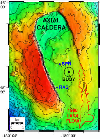 |
At left is a bathymetric map of the summit of Axial volcano, showing the caldera, the 1998 lava flow, and the components of the NeMO Net system. The NeMO Net surface buoy is anchored at the black dot and its mooring keeps it within the black watch-circle. The Bottom Pressure Recorder (BPR) and the Remote Access Sampler (RAS) are located on the seafloor at the blue dots. Both instruments have omni-directional acoustic modems and communicate with the surface buoy.
|
|||
| NeMO Home |About NeMO | Expeditions | NeMO Net | Explore | Dive! | Education |