| |
| |
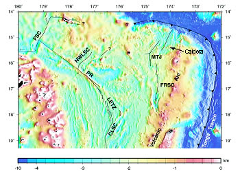
Geometry of the Lau Basin study site. |
2008 Expedition to Lau Basin
Background
The region combines arc, backarc, and a trench/backarc intersection all in one small area, which makes this a unique region that has never been explored in any detail for volcanic and hydrothermal activity. In addition, a very large oceanic plume of volcanic helium is present to the east of this region, suggesting that somewhere within the NE Lau Basin there exists a large and extensive volcanic source [Lupton et al., 2003]. Although a separate cruise has not yet been devoted to this region, a considerable amount of data has been gathered by piggybacking on other cruises. As shown by the inset map, the tectonics of this region are quite interesting. The Lau Basin hosts the back-arc spreading center of the Tonga-Kermadec subduction system. It has a fairly simple geometry south of latitude 19°S, but north of about 18°S the back-arc extension of the Central Lau Spreading Center (CLSC) splits into three different spreading zones: the Fornualei Rift and Spreading Center and Mangatolo Triple Junction (FRSC and MTJ), the Northwest Lau Spreading Center (NWLSC), and the Futuna Spreading Center (FSC). The highest spreading rate occurs in the northeastern part of this system, and there are indications that several active hydrothermal systems exist in this region. As mentioned above, this region hosts a combined arc, backarc, and trench intersection all in one small area, making it particularly interesting for biological investigations. Limited exploration of the region demonstrated that both the Fornualei Rift and the Mangatolo Triple Junction host active hydrothermal systems [Lupton, unpublished data; German et al., 2006], but they have not been confirmed visually or been visited using manned or robotic submersibles. In addition to the rift zones, the large volcanic caldera to the east of the MTJ suggests a major center of volcanic activity (see inset map). A detailed sidescan and bathymetric survey showed that the floor of this caldera is paved with fresh sheet flows [R. Arculus, private comm.]. A single hydrocast into the caldera yielded very high 3He values, suggesting the existence of a local hydrothermal source, probably located within the caldera walls. Finally, as mentioned above, the NE Lau Basin is of global interest due to the existence of an extensive and persistent helium plume of volcanic/hydrothermal origin centered at about 1700-m depth as reported by Lupton et al. [2003]. Although the source of the plume is not known, the strongest signal is centered near the NE Lau Basin, thus making the rift zones and volcanic centers of the NE Lau prime targets for the plume source.
References:
Lupton, J.E., D.G. Pyle, W. J. Jenkins, R. Greene, and L. Evans, Evidence for an extensive hydrothermal plume in the Tonga-Fiji region of the south Pacific, Geochem. Geophys. Geosyst., 5, Q01003, doi:10.1029/2003GC000607, 2003.
German, C.R., E.T. Baker, D.P. Connelly, J.E. Lupton, J. Resing, R.D. Prien, S.L. Walker, H.N. Edmonds, and C.H. Langmuir (2006): Hydrothermal exploration of the Fonualei Rift and Spreading Center and the North East Lau Spreading Center. Geochem. Geophys. Geosyst., 7, Q11022, doi: 10.1029/2006GC001324.
Lau Basin: Background | Science Team
updated 10/9/2008 |
|