P16N-2015
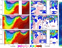
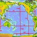
A hydrographic survey was conducted in the Pacific Ocean aboard the NOAA ship Ronald H Brown from 10 April - 25 June 2015. A total of 207 rosette/CTD/LADCP stations were occupied on a transect running roughly along longitude 152°W. CTD casts extended to within 10 meters of the seafloor and up to 24 water samples were collected throughout the water column. CTDO (conductivity, temperature, pressure, oxygen), transmissometer, fluorometer, and LADCP (lowered acoustic Doppler current profiler) electronic data; rosette water samples; and underway shipboard ADCP and carbon dioxide (CO2) measurements were collected during the survey.
Carbon Data
CTD and other hydrographic data
Section designation: P16N
Leg 1:
Chief Scientists, Dr. Jessica Cross and Dr. Samantha Siedlecki
Dates: 2015 April 10 to 2015 May 13
Ship: NOAA SHIP RONALD H BROWN
Ports of call: Papeete, Tahiti, French Polynesia - Honolulu, HI
Number of stations: 113
Geographic boundaries: 16.5°S to 22.5°N by 152°W
Leg 2:
Chief Scientists, Dr. Alison Macdonald and Dr. Sabine Mecking
Dates: 2015 May 25 to 2015 June 27
Ship: NOAA SHIP RONALD H BROWN
Ports of call: Honolulu, HI - Seattle, WA
Number of stations: 95
Geographic boundaries: 22.5°N to 56.79°N by 153.34°W to 135.95°W


