About the images from the North Pole
Also see General Information about the North Pole environment.
|
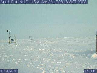
NOAA/PMEL's first North Pole Web Cam was deployed on April 28, 2002. Since then, new web cams are deployed in Spring (April or May).
In order to conserve power and reduce satellite transmission time, web cams are programmed to send a limited number of images per day from the North Pole. The cameras are dynamically programmable, so PMEL can communicate with the cameras to change many configuration parameters, such as camera angle, zoom, etc., at any time. The images from the camera track the North Pole snow cover, weather conditions and the status of PMEL's North Pole instrumentation, which includes meteorological and ice sensors seen in the camera images. The North Pole is in winter darkness from October until March.
Location: The web cam and instruments you see in the photos were deployed on an ice floe at the North Pole. On the horizon, you see the pressure ridge at the edge of the ice flow. Because the ice floes are drifting with the wind, the location (latitude and longitude) of the camera changes every day. Links to the drift path of the ice flow where the instrumentation and the web cams were deployed are found with the "Weather Data" for each deployment year, under the photos on the Web Cam home page.
Temperature, Pressure, etc.: The temperature and other environmental measurements you see in the left corner of the picture are correct. The temperature shown on the image is the temperature of the camera, and may be warmer than the surrounding air temperature (think about how your car heats up on a sunny day). Because it is spring, the temperatures are warmer than they are in the middle of winter, when the temperatures are near -30 deg C. Also the ocean water below the ice floes is near the freezing point for salt water (-1.7 deg C), so this helps keep the temperatures higher than they would be on land. Scientific measurements of temperature and other environmental parameters are found under "Weather Data" for each deployment year, under the photos on the Web Cam home page.
Time/date of photographs: The photograph was taken at the date and time shown at the top of the image. The date/time is given as Greenwich Mean Time (GMT), which is the time at the "Greenwich meridian", a north-south longitude line passing through Greenwich, England. (GMT is also called UTC, or Universal Coordinated Time). To convert the GMT/UTC to the U.S. East Coast time zone, subtract 4 hours. To convert the GMT/UTC to the US West Coast or Pacific time zone, subtract 7 hours from the GMT/UTC time. Ignore the number shown in the lower right corner of some of the images, which is an internal camera system number.
Data from the instruments you see in the photos: Realtime data from the instruments in the photographs is under "Weather Data" for each year's deployment, under the photos on the Web Cam home page and from the North Pole Observatory web site mentioned in the acknowledgments.
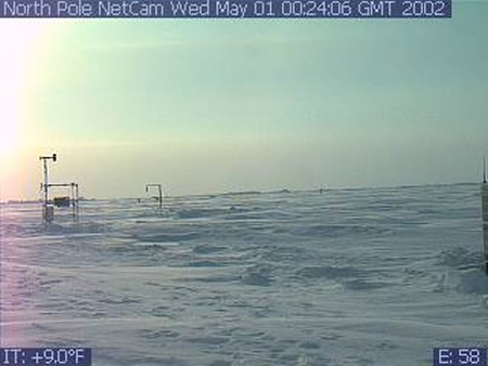 Colors in the photographs: One point to notice is that the midnight sun is already above the horizon 24 hours a day at this location for the first of May. The colors you see in the photographs are correct. For example the rosy colors in the image to the right are normal twilight colors at the North Pole.
Read about what we learned from the photos :
Click here to calculate sunrise/sunset times for any location on the earth.
| The North Pole Web Cam is part of the North Pole Environmental Observatory, a joint National Science Foundation-sponsored effort by the Polar Science Center, / APL / UW, the Pacific Marine Environmental Laboratory / NOAA, the Japan Marine Science and Technology Center, Oregon State University, and Cold Regions Research and Engineering Laboratory. |